Is Water Quality a Red Herring in the Quest for Land Control?

Water Quality. We hear the term in the news, in press conferences, and in editorials surrounding the Environmental Protection Agency (EPA), and Minnesota Governor Mark Dayton’s proposals to regulate land use primarily in agricultural areas. What is water quality, and what does it have to do with land control?

 
The Environmental Protection Agency’s proposed Rule, which would redefine what the term “waters of the U.S.” means, has a host of issues. However, the way they are selling their proposed change is in the name of water quality. Thing is, their rule change has nothing to do with water quality, since all the waters in question are already covered by the Clean Water Act. What it does talk about at length, is jurisdiction. The EPA thinks it can do a better job at implementing the provisions of the Clean Water Act than the states can. I don’t know about your state, but Minnesota is doing a great job at identifying impaired waters, establishing a game plan, and achieving it. Personally, I think states, who involve people who live and work in the watershed, are much more effective at protecting water quality than Washington bureaucrats who have probably never set foot in the watershed they are trying to regulate.

 
So, what is the point of redefining what constitutes a water of the United States if it isn’t going to change the national water quality standards outlined in the Clean Water Act? Could it be power? Control over agricultural lands? The Rule would broaden the scope of the EPA, and basically puts them in the business of regulating a farmer’s activities, which is not what Congress intended. If your land happens to be within the boundaries of the newly defined significant nexus, you may need a permit from the EPA to do ordinary farming practices. Farmers are already working towards the water quality goals of the watersheds their land is in. On our farm, we have taken advantage of voluntary programs, and federal farm programs that encourage soil and water conservation. We have planted marginal lands into Conservation Reserve Program grasslands, planted living snow fences, and use cover crops. Soil samples, plant tissue samples, and manure samples are tested to determine the correct rate of manure application each fall. We are doing what we can to meet or exceed the standards set for the watershed our land is in.

 
Redefining the Waters of the United States in the name of water quality is deceiving…a red herring. The EPA is simply looking for more ways to control what happens on the land. Land owned by farmers and landowners who are already complying with CWA standards.

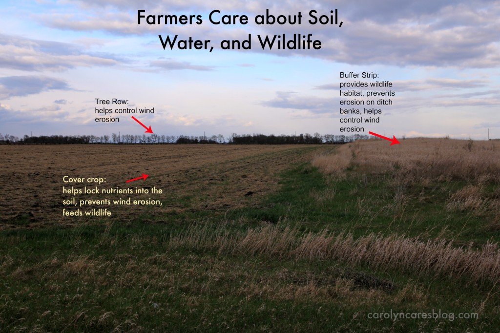
farmers care about soil, water, and wildlife

Water quality has also been a hot topic on the state level in a few states lately. In Minnesota, Governor Mark Dayton has asked for a 50 foot riparian buffer strip along all rivers, streams, and ditch banks and everywhere water flows “most of the time”. Sounds good on the surface, but like the EPA’s WOTUS rule, the Governor’s plan has some major flaws.

 
Farmers are not opposed to buffers. In the right locations, at the appropriate width designed for that particular location, they can be very effective. One-size-fits-all makes no sense if the goal is improving water quality. However, the news media has been blasting agriculture for not doing their part to improve water quality, and is telling the public that we need these buffer strips to achieve water quality. When I read the proposed Senate and House bills, I was puzzled. What exactly is this water quality they are talking about? Under the Purpose of the bill, it lists “protecting water from runoff and erosion; stabilizing soils, shores, and banks; and provide aquatic and wildlife habitat.” (HF1534, MN House of Representatives) Is that what water quality is? If that is the state’s definition of water quality, we can achieve that in without a mandatory, one-size-fits-all 50 foot buffer strip.


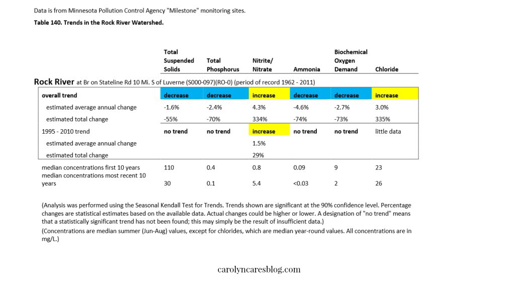
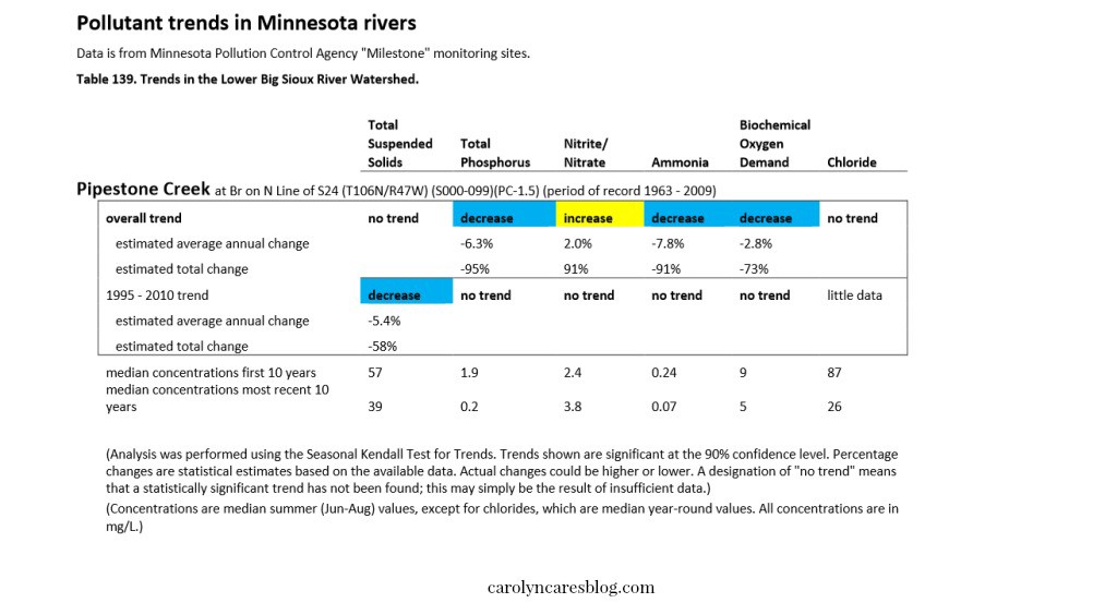
One of the Governor’s reasons for the need for the 50 foot buffer strip is the Minnesota Pollution Control Agency’s latest report on the Missouri River Basin in Southwest Minnesota. As I was reading the full report, a few things stood out. Governor Dayton kept referring to how bad the water quality is, but the same report that had the media blasting agriculture for all the water woes also contained some positive news. Two of the major watersheds had improved water quality over the past 10 years. Pipestone Creek and the Rock River both showed decreases in Total Suspended Solids and Total Phosphorus, two areas of assessment that is mentioned many times in the MPCA’s report.

pipestone creek water quality improvement

rock river water quality improvement

The other thing that I noticed is that there is no water quality standard for Total Phosphorus in streams, and there are no Nitrite/Nitrate standards in streams or lakes. When reading the chemistry results from the tested waters – where there were water chemistry reports – there were numbers present, but no parameters for TP or Nitrite/Nitrogen. If there are no water quality standards, or water quality goals, how can we know if we have achieved the desired result?

 
The idea of no water quality standard or goal in the proposed bill was brought up at the Governor’s Buffer Strip Session in Worthington, Minnesota. I was happy the gentleman asked the question, since I had noticed the lack of goals in the bill, but just thought I was missing a point. That question raises another one. If there are no Total Phosphorus standards for streams, how are we to know when we have reached an achievable goal? Is it the historic levels dating back before the European settlements? What if those numbers were historically high, even before the prairies were turned in to farmland? Are we just going to be chasing an unachievable number?

 
Spring Lake, near Prior Lake recently made a request to the EPA to change the standard for Total Phosphorus from 40 ppb to 60 ppb after a lake sediment core was studied, and it found that Spring Lake historically was high in Total Phosphorus. So, if TP was high before the land surrounding Spring Lake was turned into farmland, is it agriculture solely to blame? I don’t think so.

 
It remains that there are no true water quality standards set out in Governor Dayton’s Buffer Strip bill. Even when farmers are accused of not doing their part to improve water quality, the MPCA’s own documents show otherwise. So, if there is no true water quality standard in the bill, using water quality as the selling point is deceiving…a red herring. What is it that the Governor truly wants? More land.

 
In December, the Governor held a Pheasant Summit to address the decline in the pheasant population in Minnesota. It was there that the first mentions of a 50 foot buffer strip plan were heard. When the Governor announced his plan a few weeks later, it was not met with much enthusiasm. In January, the buffer strip idea was introduced as a way to increase water quality. Water quality is an emotional subject, and has been used as a rallying cry for the Governor’s plan to put the Department of Natural Resources in charge of those 50 foot buffers on privately owned land. In the name of water quality, farmers have been raked through the mud and have been characterized as being uncaring polluters. As mentioned above, we do many things to improve water and soil conservation on our farm. We care about water quality just as much as our friends in town do. We drink the water from our wells, we bathe in it, we use the water for recreation, and we depend on the rain for our crops. Jonathan and I are not unique in that aspect.

 
If the EPA or the Governor were truly more interested in water quality than control of property rights, they would support incentives for farmers, businesses and non-farmer land owners that allow for an individualized approach that takes into account the unique features of that property. Both entities need to quit deceiving the public, and call their proposals what they really are: A quest for the control of the landowner’s private property.
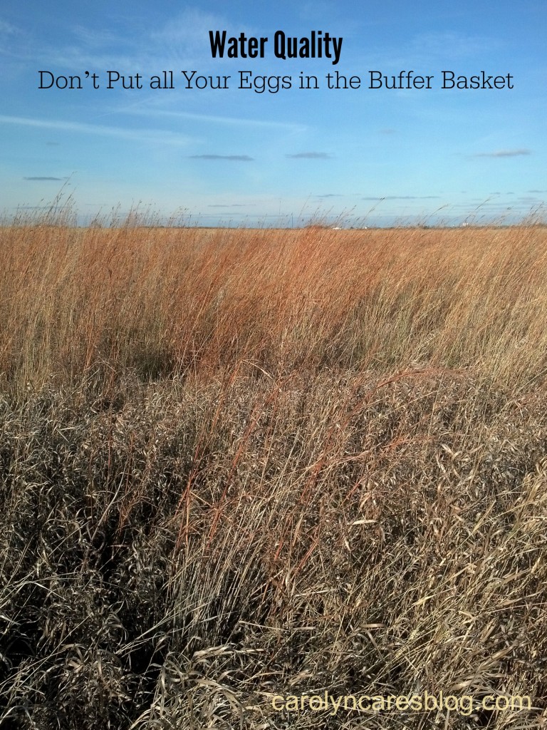
Water Quality – Don’t Put all Your Eggs in the Buffer Basket

Buffer strip

In January, Minnesota’s Governor Mark Dayton announced a plan to require a 50 foot buffer strip along all rivers, streams, and drainage ditches in the state. Mandating a set buffer strip width for all of those waterways means topography, soil types, and surrounding land use will no longer be determining factors in buffer strip width. This one-size-fits-all approach won’t improve water quality like we’ve been told it will.
The NRCS (Natural Resources Conservation Services) published a report in 2000 that talked about the different types of water control features that would help trap soil, nutrient, and pesticides, which would help to improve water quality. In the report, they stated how using multiple methods was more effective than a single method for controlling water flow, water filtration, and pesticide trapping. Many improvements have been made in the 15 years since this report was published. Let me highlight a few for you.

Cover crops

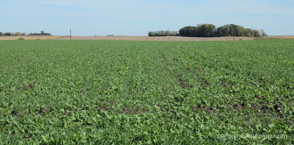
The use of cover crops is a relatively new trend in our area. Cover crops are a blend of plants grown for their ability to prevent soil erosion, manage water and water quality, suppress weeds, and hold soil nutrients in place. We plant our cover crops right after our wheat is harvested which will give the plants enough time to grow well and be more effective. Other farmers will use airplanes to spread the seed before their row crop is harvested. In the 14 years that we have been growing cover crops, we have experimented with different seed mixes until we found what works best on our soil. The combination of tillage radishes and oats that we use provides two very different types of plants which is also beneficial for wildlife. The deer graze on the tillage radish leaves, and pheasants use the taller oats for cover. This is a win-win for water quality, soil health, and wildlife.

Field Mapping

Global Positioning Systems (GPS), broadband internet, and computers in combines and tractors have made it possible to create accurate maps of every field. These maps are uploaded onto a computer, where we can then work with our local agronomist to determine what recipe each field needs to grow the crop that will be planted in it. Each recipe will be different for each field, depending on what we will be growing, the results of our soil and plant tissue tests, and the yield data from the year before. Our corn and wheat both need manure applied to supply the nutrients that the plants need to grow well. However, they do not require the same amount of manure, so we follow the recipes to make sure we are not using too much manure on the fields. We like to use cover crops as part of our recipe for our corn fields, since the tillage radish helps to keep the nutrients from the manure where the corn roots will be. This combination of conservation methods works great over an entire field to keep soil and nutrients from eroding, and doesn’t just rely on the last 50 feet before a water way.

Precision Equipment

Fifteen years ago, I never imagined all of the things computers and information technology could do for agriculture. Of course, at that time, I was still using a Nokia cell phone with an external antenna, and the iPhone was still 7 years away from being released. Now, besides most farmers having smart phones, there are computers in tractors, fertilizer spreaders, and sprayers. These computers allow farmers to use their field recipes as they are driving up and down the fields, many times driving with the aid of GPS auto guidance systems. The Precision Planting computer we have in our tractor helps our planter keep the seed planting depth at the perfect level through the variations in the firmness of the soil, varies the amount of seeds per acre according to soil type, and will shut off boxes at the end of the rows or where the rows overlap on curves so we don’t waste seed. We work with our Precision Planting Specialist to make sure our recipes are entered into to the computer correctly, and that the equipment is communicating with the computer. Fertilizer spreaders with variable rate technology are used by our friends. Their field maps and recipes are loaded into the computer, and the fertilizer is spread where it is needed. A similar system is used with sprayers when applying pesticides. The field map can be set up to avoid spraying in certain sensitive areas, and to avoid overlapping the spray with auto shut off valves. We don’t use fertilizer spreaders or sprayers on our farm, so I would encourage you to go to your favorite farmer or The Farmer’s Life if you have questions.

Flexibility is needed

On our farm, we have planted some buffer strips with the help of our NRCS Conservationist and local Soil and Water Conservation District (SWCD). On one ditch where the ditch bank rises to the edge we have a very narrow grass buffer, which is all that is needed. We are also using cover crops, field mapping, and precision equipment. This multi-pronged approach to water quality, soil health, and wildlife habitat is a better approach than a mandate of every river, stream, and drainage ditch needing a 50 foot buffer. Some ditches or streams do not need a grass buffer, while some could benefit from one that is greater than 50 feet. Every farmer should be able to figure out what conservation practices will work best on their farm, and should be able to change those practices when needed. Farmers want to be able to hand down their land to the next generation. To do that, we need to care for the soil and water in the best ways we can. Putting all of our water quality eggs into one basket isn’t the best way to achieve that.
To read more on how this buffer strip proposal would affect Minnesotans, I highly recommend that you read this post by Sara Hewitt.

cover crop of tillage radish and oats
A field planted with a tillage radish and oat cover crop


Why Minnesotans Should Be Wary of the EPA’s Rule

I live in Minnesota, land of 10,000 lakes. Or, more precisely, 11,842 lakes that are 10 acres or larger, 6564 natural streams and rivers, and 10.6 million acres of wetlands. (source: MN DNR) Water is a big deal in Minnesota, not only for the impact on agriculture, but also as a major source of recreation and revenue from those activities. Our outdoor industry is so important, that we have a state law in effect that schools cannot start until after Labor Day so that families can enjoy one more weekend at their favorite resort or lake. There are a few exceptions, but the residents of those districts are split on whether or not it’s a good thing to start school before the last long weekend of the summer.
When I first heard about the proposed rule that the Environmental Protection Agency filed earlier this year, I was undecided as to whether or not it was a good or bad thing. The more I read, the more I became concerned. The rule is supposed to provide clarification to what some of the terminology of the Clean Water Act (CWA) means. The rule doesn’t change the fact that waters will be assessed, monitored, or cleaned up. There is no language in the rule that changes the basic CWA. What does change is who is in charge of enforcing the assessing, monitoring, and cleaning up. I have a problem with that.
It is important to know what the definition is of paragraph (s)(1) through (4) says, since it is referenced in many parts of the rule.
“(s) For purposes of all sections of the Clean Water Act, 33 U.S.C. 1251 et seq. and its implementing
regulations, subject to the exclusions in paragraph (t) of this section, the term “waters of the United
States” means:
(1) All waters which are currently used, were used in the past, or may be susceptible to use in interstate
or foreign commerce, including all waters which are subject to the ebb and flow of the tide;
(2) All interstate waters, including interstate wetlands;
(3) The territorial seas;
(4) All impoundments of waters identified in paragraphs (s)(1) through (3) and (5) of this section”

The rule says that ditches are exempt if they meet these criteria:
“(3) Ditches that are excavated wholly in uplands, drain only uplands, and have less than perennial flow.
(4) Ditches that do not contribute flow, either directly or through another water, to a water identified in
paragraphs (s)(1) through (4) of this section.” According to this definition, the exempted ditches as listed are not really exempted…because all ditches in Minnesota run “either directly or through another water, to a water identified in paragraph(s)(1) through (4) of this section.” This means that the EPA will basically have control of every single ditch in Minnesota….agricultural, municipal, wherever. We have so many lakes, rivers, streams, and wetlands, that it is pretty much impossible for any ditch to qualify for this exemption.

The rule goes on to try to define what “significant nexus” means. This is where I think it really gets worrisome for Minnesotans.
“The term significant nexus means that a water, including wetlands, either alone or in combination with other similarly situated waters in the region (i.e., the watershed that drains to the nearest water identified in paragraphs (s)(1) through (3) of this section), significantly affects the chemical, physical, or biological integrity of a water identified in paragraphs (s)(1) through (3) of this section. For an effect to be significant, it must be more than speculative or insubstantial. Other waters, including wetlands, are similarly situated when they perform similar functions and are located sufficiently close together or sufficiently close to a “water of the United States” so that they can be evaluated as a single landscape unit with regard to their effect on the chemical, physical, or biological integrity of a water identified in paragraphs (s)(1) through (3) of this section.”

Remembering back to Mr. Emmon’s Earth Science class at Jackson Junior High in Champlin, and the lessons on how water moves makes this definition of significant nexus pretty inclusive of all water in Minnesota. When you look at a watershed map from your county Soil and Water Conservation District, or the Natural Resources Conservation Service you will see that all of the waters in Minnesota flow to the Red River of the North, the Rainy River, Great Lakes basin, Mississippi River, or Missouri River. All of those basins are interstate waters. This would mean that the EPA would have control of all water in Minnesota.

So, why do I have a problem with that? Minnesota has done a great job of implementing the parts of the Clean Water Act that the states were given the authority over. The Clean Water Council is made up of stakeholders representing all areas affected by the rules of the CWA, and those interested in the environment. Who better to help oversee waters in Minnesota, than those who are directly affected by, and care about, the waters in Minnesota? If the EPA’s Rule doesn’t change the fact that the waters are going to be cleaned up where necessary, what is the point of the Rule? It looks more like a control issue than a clarification issue to me. This is why I think we need to #DitchtheRule.

Join me in contacting the EPA and the Army Corp of Engineers asking them to withdraw the proposed rule. A rule that won’t change which waters are regulated, but one that shifts authority away from Minnesotans and into the hands of Washington D.C. bureaucrats.

(Click here to read the EPA’s proposed rule)
(Click here for more information about Farm Bureau’s Ditch the Rule)
(Click here for the Minnesota Farm Bureau Clean Water Act links)

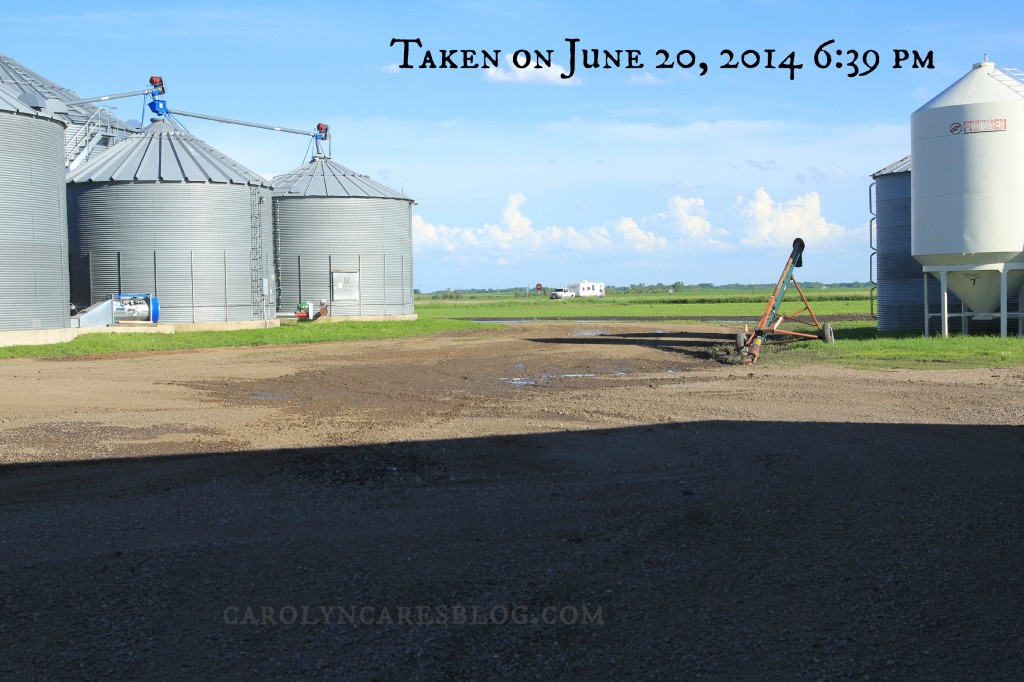
CarolynCares Flooding
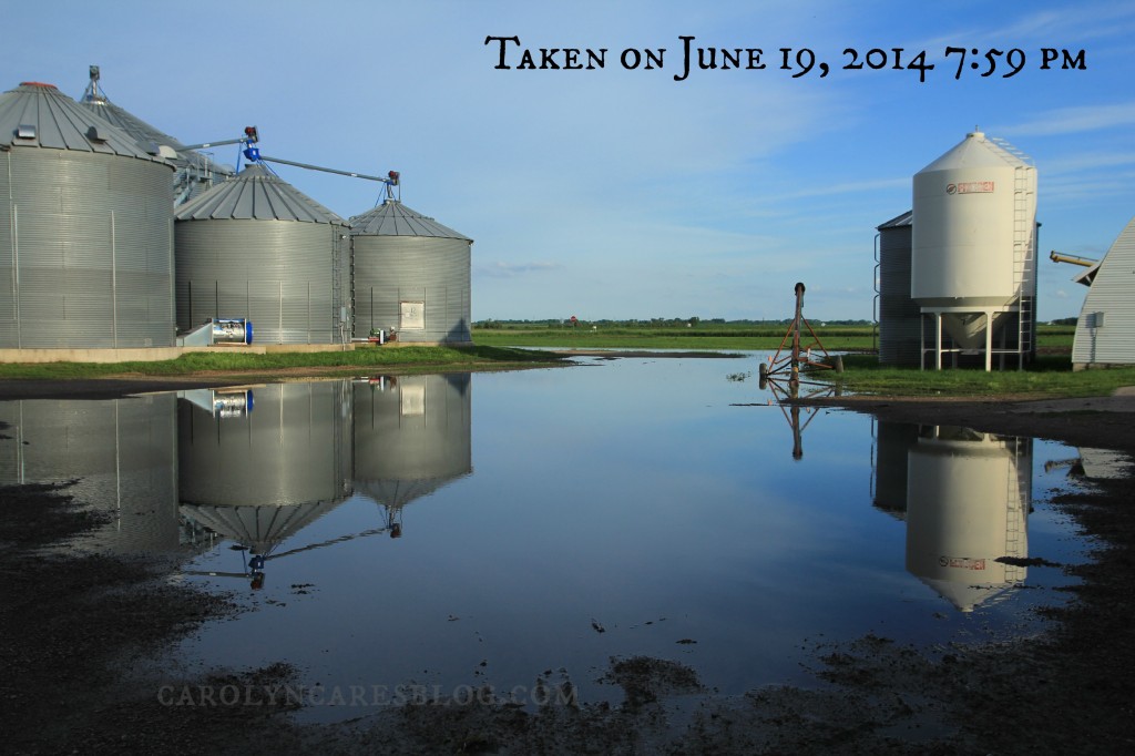
A large puddle in our farm yard

.

Same location, 22 hours later. This could be under EPA jurisdiction, due to the watershed this puddle was in.
Same location, 22 hours later. This water went into the Redwood River Watershed, which ultimately leads to the Mississippi River.